Constructed Wetlands in Canberra, ACT.


Applying the Global Standard for Nature-based solutions: the case of constructed wetlands in Canberra, Australia
This research explores the application of the 'Global Standard for Nature-based Solutions' (IUCN 2020)1 in the context of constructed wetlands in Canberra, Australia. The aim is twofold. First, to verify that these wetlands are indeed an NbS intervention in the terms described in the Standard, and if so, measure the 'strength' of that intervention; and second, to identify any difficulties in applying the Standard in the Canberra context.
Constructed wetlands (CWs) ‘are engineered systems that have been designed and constructed to utilize the natural processes involving wetland vegetation, soils, and the associated microbial assemblages to assist in treating wastewaters. They are designed to take advantage of many of the same processes that occur in natural wetlands, but do so within a more controlled environment’2.
In Canberra, the first phase of wetland construction was between 2006 and 2014, with 6 wetlands established. Five of the 6 were in a small urban catchment (Sullivans Creek) in Canberra's north3. The second phase began in 2017 under the aegis of the 'ACT Healthy Waterways Project’4. This was a joint initiative of the ACT and Australian governments with the aim of protecting and improving ‘long-term water quality in the ACT and further downstream in the Murrumbidgee River system’ via a reduction in the level of nutrients, sediments and pollutants entering Canberra’s lakes and waterways5. Twenty infrastructure projects were undertaken across 6 urban catchments between 2017 and 2019, with an on-going program of macrophyte establishment. Construction was not limited to wetlands - ponds, rain gardens, swales, creek restoration and channel reconnection were part of these important green infrastructure developments.
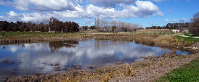
Constructed wetland, Narrabundah, Canberra, ACT (Photo: RJ Carne). This photo shows one of the 7 pools (no.3 in image below) which comprise this wetland.

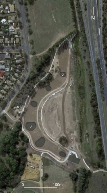
Constructed within the Jerrabomberra Creek, the Narrabundah wetland comprises a chain of open water ponds separated by shallows planted to macrophytes. This configuration emulates the so-called 'chain-of-ponds' noted by early explorers to the area. In well-defined channels, these features consisted of ponds separated by fine sediment stabilised by reeds6 (possibly very similar to what has been constructed here). This morphology appears to have been characteristic of many of the smaller streams including the Burra Creek, a tributary of the Queanbeyan River which is shown on the earliest survey plans - around 1836 - as a 'chain-of-ponds' 7.
Photo below shows a view across pool 6.
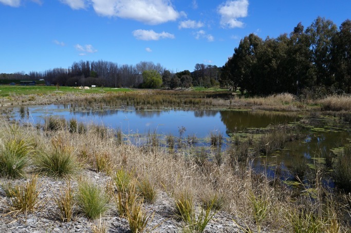
Narrabundah wetland - view across pool 6 (Photo: RJCarne).

References:
-
1.International Union for the Conservation of Nature (IUCN) 2020, IUCN global standard for nature-based solutions: a user-friendly framework for the verification, design and scaling up of NbS, First edition, IUCN, retrieved 24 July 2020, <https://portals.iucn.org/library/node/49070>.
-
2.J Vymazal, ‘Constructed wetlands for wastewater treatment: five decades of experience’, Environmental Science & Technology, vol.45, no. 1, 2011, pp. 61-69.
-
3.ACT Government, Constructed wetlands, Environment, Planning and Sustainable Development Directorate: Environment, 2020, retrieved 29 July 2020, <https://www.environment.act.gov.au/water/constructed_wetlands>.
-
4.ACT Government, ACT Healthy Waterways Project, ACT Healthy Waterways, 2020, retrieved 29 July 2020, <https://www.environment.act.gov.au/water/ACT-Healthy-Waterways/healthy-waterways/act-healthy-waterways-project>.
-
5.ibid.
-
6.RJ Eyles, ‘Changes in drainage networks since 1820, Southern Tablelands, NSW’, Australian Geographer, vol. 13, 1977, pp. 377-386.
-
7.RJ Eyles, ‘Erosion and land use in the Burra Catchment, Queanbeyan’, Journal of the Soil Conservation Service of New South Wales, vol. 33, no. 1, 1977, pp. 47-59.
